Wednesday, September 30, 2015

Photos Taken Along Highway 118 To Granisle British Columbia


Above Photo: I took this picture of Timber Lake from the side of 
Highway 118 in-between Topley and Granisle, B.C.

I took these photos while driving up Highway 118 to Granisle, British Columbia to film the Sockeye Salmon spawning in the Fulton River Spawning Channel. The colors were so brilliant from the plants and trees, I could not pass up the chance to capture this on film. 


Above Photo: I took this picture of Timber Lake from the side of 
Highway 118 in-between Topley and Granisle, B.C.

There were a number of visitors at the facility with large signs posted to watch out for the bears as they frequent the area looking for a quick meal. 


Above Photo: I took this picture from the side of Highway 118
 in-between Topley and Granisle, B.C. as the colors of Fall really stood out.

The large numbers of spawning salmon is something to see. There are numerous spawning grounds around this great province, so be sure to check your area for one.


Above Photo: This photo is off an old home sitting in a field along side Highway 16 in-between Topley and Houston, British Columbia.

If you have a picture or story you would like to share on the Travel British Columbia with Brian Vike blog, please contact me at b_vike@telus.net

Travel British Columbia with Brian Vike.

Travel Houston, British Columbia with Brian Vike.

Tuesday, September 29, 2015

1890 Telegraph Cabin Quick British Columbia (Photos)


Above Photo: 1890 Telegraph Cabin Quick British Columbia information sign.

Here is building I have driven by for years, but never stopped to check it out, until now. 

The 1890 Telegraph Cabin in Quick, B.C. is located yards off Highway 16 to the west. You can park your vehicle to the side of the gravel road and walk into the area where the cabin sits. 


Above Photo: 1890 Telegraph Cabin Quick British Columbia.

The area was fenced off, but there is an opening so folks can get up close to take pictures, and place their hands onto some of British Columbia’s history. 

I am going to check at the Visitors Centre’s to see if they might have information on the cabin.


Above Photo: 1890 Telegraph Cabin Quick British Columbia.

Here is a Google map showing where the Telegraph Cabin sits. 
As I mentioned above, you can’t miss it as it off Highway 16.

Also there is an old bridge to be found in Quick also, Northword Magazine has a great article and photo on the old bridge at Quick, B.C., and you can find this at the following link.


Above Photo: 1890 Telegraph Cabin Quick British Columbia.


Above Photo: 1890 Telegraph Cabin Quick British Columbia.

If you have a picture or story you would like to share on the Travel British Columbia with Brian Vike blog, please contact me at b_vike@telus.net

Travel British Columbia with Brian Vike.

Travel Houston, British Columbia with Brian Vike.

Monday, September 28, 2015

Timber Kings Huge Log Home Filmed At Hudson Bay Mountain Estates Smithers B. C. (Photo)


Above Photo: This is the log home that is being built by the folks on the 
hit TV show ,the Timber Kings.

My wife, dog and I went for a drive on Sunday, September 27, 2015 to Smithers, British Columbia so I could film some of the beautiful scenery around the area, 
and there is plenty of amazing places to visit.

One of the areas we explored was at the top of the Hudson Bay Mountain Ski hill. It was raining with a low cloud ceiling, so I was not able to take a lot of photos at the top, but we did find some cabins, and other buildings to film.

Anyway, we still poked around until we came to a massive log home that was being built. When finished, it will be a beautiful home. 

Today, the 28th of September my wife was checking to see if she could find any information on the log home. To her surprise, she found the log home, and it was being built by, and filmed for the TV show, “Timber Kings”.


Above Photo: This cabin can be rented while you are up skiing on the Hudson Bay Mountain.

There was still lots to do, but at least we can give you a peak at this home. It is totally amazing, just a massive home built out of logs.

Below I have provided some links to the area where you can buy lots, it has a map showing their location, and one of those is where the home sits.

Mountain Village, The Estates. (Hudson Bay Mountain Smithers, British Columbia)

The below link shows the parcels of land that are for sale on the mountain, and also gives the prices as well. Also this is where I took the photo from. 


Hudson Bay Mountain Ski Resort Facebook Page. 
(The link takes you to Facebook and a peak at the log home as well)

Also at the below link, the Home & Garden website providing information of the Timber Kings show, you can also watch shows online as well. So check it out.


Above Photo: I believe this was a restaurant.


Above Photo: A look down the Bulkley Valley from 
Hudson Bay Mountain Smithers, British Columbia.


Above Photo: A look at another building on top of the mountain.


Above Photo: I liked the green of the evergreen trees, and the splash of yellow.


Above Photo: I like these swampy areas where you have the living and 
dead trees poking up out of the water.


Above Photo: This is one a person had to see in person, the brightness of the 
yellow was something else.

If you have a picture or story you would like to share on the Travel British Columbia with Brian Vike blog, please contact me at b_vike@telus.net

Travel British Columbia with Brian Vike.

Travel Houston, British Columbia with Brian Vike.

Sunday, September 27, 2015

Fall Colors Filmed At Seymour Lake Smithers British Columbia (Photos)


Above Photo: This photo was taken around Seymour Lake.

Seymour Lake is a small lake located approximately 3.7 kilometers from the town of Smithers, B.C. 


I have not personally fished the lake, but I hear the fishing can be good. So check it out, take a rod along with you and good luck.


Above Photo: The Fall colours seen Seymour Lake.

There is also the Seymour Ridge Trails for folks who like to go hiking, I found some information and map on the hiking trails at this Link.

Here is a map for directions from the town of Smithers to Seymour Lake, which is found on the way up to the Hudson Bay mountain ski hill.


Above Photo: The Fall colours seen Seymour Lake.

Today on September 27, 2015 my wife, dog and I went up Hudson Bay mountain in Smithers and the scenery was just awesome. The fall colors are at their best and I would recommend that if anyone enjoys observing or taking pictures of breathtaking scenery, Seymour Lake is the place to go right now. It was so pretty today I could not stop talking about the colors of the trees, plants, etc..


Above Photo: The Fall colours seen Seymour Lake.

Also there were a bunch of Canadian Geese on the lake making a heck of a sound, I guess taking a break from their long journey south. 

We did drive up to the top of the ski hill and I took photos along the way. There was some amazing sights, and you just can’t capture that on film, it is a must see.


Above Photo: The Fall colours seen Seymour Lake.

Smithers is one of those gems in British Columbia. There are so many things to do and see and I have been finding them and putting the pictures I have taken up on this Travel blog of mine. 

Over the winter months I will be writing up a large article about traveling Highway 16 from Prince George right through to Prince Rupert/Kitimat, B.C. and everything in-between.


Above Photo: The Fall colours seen Seymour Lake.


If you have a picture or story you would like to share on the Travel British Columbia with Brian Vike blog, please contact me at b_vike@telus.net

Travel British Columbia with Brian Vike.

Travel Houston, British Columbia with Brian Vike.

Saturday, September 26, 2015

Irrigation Lake/Scenery And Old Building Filmed Around Houston British Columbia (Photos)


Above Photo: The Bulkley River in Houston, British Columbia. Actually I took a picture from this very same spot in Summer. Here is a link to this. 
I also will post a winter photo from the same location as well.

My wife and I decided to get out of the home for a while and I thought I would take some new photos of the Fall colours that are present in our small town of Houston, British Columbia.

So we drove around Houston, and I snapped some photos of what we saw. 

We also headed out a short distance from Houston to a small lake, where in summer people flock to Irrigation Lake to go swimming, sunbathing, fishing, hiking and they take along a picnic basket for their lunch. You can also cook some hot-dogs and hamburgers over fire pits. There is a sandy beach for the little ones to make sandcastles, or just to dig a big hole to get lost in. There are toilets/outhouses on site, and change rooms.


Above Photo: The Bulkley River in Houston, British Columbia.

If you do decide to try your luck at fishing, only electric motors are allowed on the lake and of course you can paddle around in a canoe. Also in winter, many folks are seen out on the frozen lake ice fishing, and they do pretty good catching some nice sized trout.

Irrigation Lake is located approximately 14 km west of Houston, B.C. on Highway 16. There is a sign located on the highway to the right hand side of the road just before you get to the lake’s turnoff, giving you a heads up, but one has to be careful as the main sign/turnoff for the lake comes up really quick and I know I have had to slam on my brakes to make the left hand turn off of the highway and onto the lake’s gravel road.


Above Photo: Irrigation Lake Houston, British Columbia.

I think I might bring this up at one of the town’s meetings as it can be a bit dangerous to the public.

I also added some photos of scenery in which I took when leaving Irrigation Lake and driving back into Houston on highway 16. We finally decided to go home, but something really 
interesting caught my eye.


Above Photo: Photo taken from just outside of Houston, British Columbia on 
Yellowhead Highway 16. 


Above Photo: Photo taken from just outside of Houston, British Columbia on 
Yellowhead Highway 16. 


Above Photo: Photo taken from just outside of Houston, British Columbia on 
Yellowhead Highway 16.

I must have driven by this old building hundreds of times and never gave it a thought, or noticed it until today. So below I have added three pictures of the old building. I will check in town to see if there is any records on the building.


Above Photo: Photo taken from downtown Houston, British Columbia.


Above Photo: Photo taken from downtown Houston, British Columbia. The above and below pictures puts me in mind of a witch that may pop out of the building and and drop me in her large cooking pot. Or maybe something out of a movie. 


Above Photo: Photo taken from downtown Houston, British Columbia.

If you have a picture or story you would like to share on the Travel British Columbia with Brian Vike blog, please contact me at b_vike@telus.net

Travel British Columbia with Brian Vike.

Travel Houston, British Columbia with Brian Vike.

Thursday, September 24, 2015

Ksan First Nations Historical Village In Hazelton British Columbia Canada


I thought I would post one of a number of photos I have taken at the Ksan Historical Village in Hazelton, British Columbia. Eventually I will get everything added to the blog, a story along with a lot of photos from the Village. I really enjoyed looking at everything, and of course taking photos and sharing them.

Besides the Ksan Historical Village, I stopped in Old Hazelton, and took a lot of photos of the old town. Some cool photos from there as well.

If you have a picture or story you would like to share on the Travel British Columbia with Brian Vike blog, please contact me at b_vike@telus.net

Travel British Columbia with Brian Vike.

Travel Houston, British Columbia with Brian Vike.

Sunday, September 20, 2015

Usk Pioneer Chapel And A Memorial To The Fallen Loggers (Photos)


Above Photo: Usk Pioneer Chapel.

Continuing on our travels from Seeley Lake Provincial Park British Columbia, we found something of interest in the small community of Usk, B.C., right along side Highway 16. 

There sat on the side of the highway, a church. The sign read, Usk Pioneer Chapel, visitors welcome. For some reason it looked out of place to me, but it didn’t take long to see why it was there, and I think for many who took the time to stop, it was a place to worship. 

I did some looking around the internet and found information on this, and it is really interesting. I have provided a link to the story below.

Usk Pioneer Chapel.


Above Photo: Usk Pioneer Chapel.

Also on the same grounds, there is a really nice memorial, it is in memory of the men who lost their lives working in the forest industry.

On the memorial is a plague anchored to rock, dedicating it to the men who lost their lives, and spread around on the memorial are hard hats, tension tie downs, chains, boots and suspenders. Also directly beside this, is another memorial which lists all the names of the men who lost their lives in the logging industry. 


Above Photo: Memorial to the fallen loggers here in British Columbia.

Also on the site, is a large figure of a man all craved out of wood, holding a large saw. 

There is a newspaper article I found online about the making of the Woodworkers memorial through the Terrace Standard Newspaper. You can read it at the following link.

Fallen Loggers Remembered:


Above Photo: Memorial to the fallen loggers here in British Columbia.


Above Photo: Memorial to the fallen loggers, and a list of there names here in British Columbia. You can click on any of the photos for a larger view.

From the Usk Pioneer Chapel and the memorial to the Woodworkers, the folks who put all of this together should be very proud of themselves, and I was glad I decided to stop and learn a little bit more history about this great province of ours, British Columbia.


Above Photo: Memorial to the fallen loggers.

If you have a picture or story you would like to share on the Travel British Columbia with Brian Vike blog, please contact me at b_vike@telus.net

Travel British Columbia with Brian Vike.

Travel Houston, British Columbia with Brian Vike.

Saturday, September 19, 2015

Seeley Lake Provincial Park British Columbia Canada (Photos)


Above Photo: Sign for the Seeley Lake Provincial Park British Columbia. 

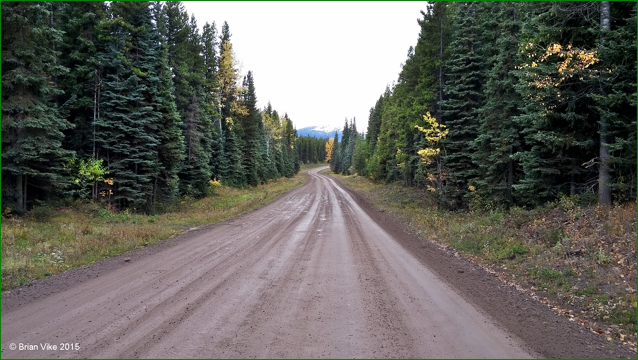
Continuing our journey from Terrace on our way back home to Houston, B.C., we stopped at a very scenic place called Seeley Lake, which is a British Columbia Provincial Park. Now if you haven’t been there and will be traveling this way, you have to stop. The lake sits right along side the Yellowhead Highway, which has been designated as Highway 16.

Below I have a link to a map which gives the location of the Seeley Lake Provincial Park. 


The park is beautiful, the backdrop of mountains will blow you away. The mountain tops are jagged, with a fresh bit of snow. As your eyes make their way down the mountain, you see a carpet of green that covers the barren rock until it finally meets the shores of Seeley Lake. The Fall colours are starting to show, with the leaves turning red and golden yellow. There is one thing about living in British Columbia, is that we have four distinct seasons and everyone one of them is as beautiful as you will find anywhere.


Above Photo: The Fall colours are showing.

When we pulled off the Highway, another vehicle came to a stop in the parking lot, you could hear the couple shouting out, “amazing”, and off they went to snap a bunch of photos.

We did speak to them and they were heading to Alaska, but they first wanted to take a side trip and stop in Stewart B.C., then drive across the border into Hyder, Alaska to take in the Salmon Glacier, and stop at the famous Glacier Inn to get Hyderized, which is a good shot of 150 proof alcohol. I have been to Hyder myself a couple of times, but I still haven’t been Hyderized. I believe the couples final destination was Haines, Alaska. 

Seeley Lake Provincial Park is a provincial park in British Columbia, Canada, located south of the confluence of the Skeena and Bulkley River at Hazelton, and to the south of that settlement.


Above Photo: Sealy Lake and "Medeek". 
Also note that there seems to be two different spellings for the lake.

The Seeley Lake Park is approximately 24 hectares in size, it has  really nice campground and there are 20 campsites available and pit toilets in and around the campsites.

You can have campfires in the park, but please check to see if there might be a ban on campfires due to the hot dry weather.


 The park provides a day-use picnic area right on the shoreline of Seeley Lake. While eating your lunch, you will have a wonderful scenic view of the mountains, which are truly beautiful.

People from around the area, and travelers swim at the lake, and others bird watch or keep their eye open for other wildlife.


 Above Photo: Mountain and forest reflection on the calm Seeley Lake.

There is water in the park, it is situated in the parking lot by way of a hand pump. Not only do you get your water, but also a workout while pumping the water into your container. 

There also is a wildlife viewing platform located at the waters edge on Seeley Lake, just take a short hike on the walking trail to the platform. Information on the trail is located at the lake.

Pets are allowed, but please have your pet on a leash at all time. Also your pet is not allowed in beach areas or in park buildings. Make sure you have a bag to pick up your pets droppings.

There is fishing for cutthroat and rainbow trout in Seeley Lake.


 Above Photo: Jagged mountain top with snow.

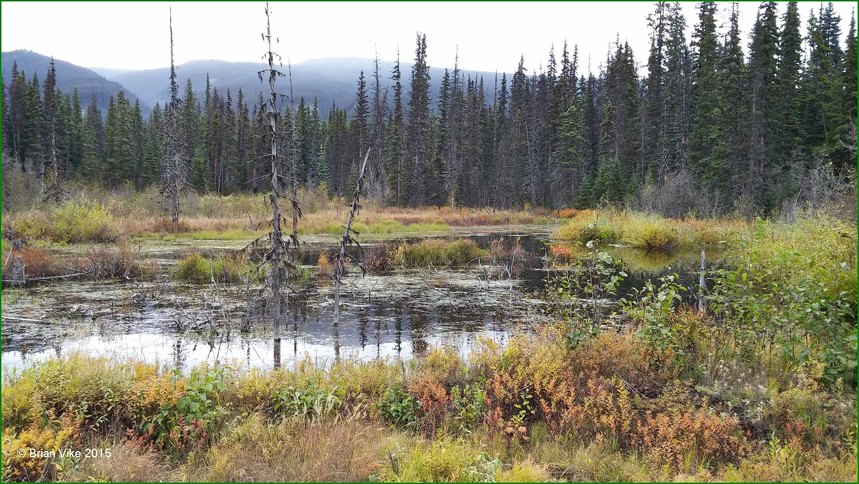
Canoeing through the marsh area at Seeley Lake is rewarding with the backdrop of the Hazelton Mountains. Electric motors only are allowed in Seeley Lake and there is no boat launch available.

In the winter months, you can ice skate or try your luck at ice fishing on the lake, but always check the thickness for safety sake.


 For more information on the Seeley Lake Provincial Park.

Our next stop is at New Hazelton at the Visitors Centre. Boy do they have some awesome characters outside on the grounds. They really have a nice centre for their visitors.

Plus after that, the Ksan Historical Village. So lots to come.

If you have a picture or story you would like to share on the Travel British Columbia with Brian Vike blog, please contact me at b_vike@telus.net

Travel British Columbia with Brian Vike.

Travel Houston, British Columbia with Brian Vike.

Friday, September 18, 2015

Old Skeena Bridge Over The Skeena River Terrace British Columbia (Photo/Video)


Above Photo: The Terrace, British Columbia Visitor/Kermode Tourism Centre. "Location Map".

Our last stop was in Moricetown, British Columbia, where I filmed the First Nation people fishing on the Bulkley River. From Moricetown I drove almost directly to Terrace so I wouldn’t miss my appointment. I did a couple of fast stops, but they were quick.

Later that day, I stop by the Terrace visitor’s centre, grabbed a picture and then went looking for the Old Skeena Bridge. Lucky for me it was visible from another bridge on Highway 16.

I parked the car at the side of Highway 16 and walked back to where I could see, and get a photo, and video of the old Skeena Bridge crossing the Skeena River. I must admit, it was pretty cool.

From there we started to head back toward home, stopping at a few different places a long the way. 

Below text information from Wikipedia, the free encyclopedia.

The Old Skeena Bridge officially opened July 1925, halting the use of the Ferry Island ferry service to Thornhill Creek. In 1944, the Skeena River Highway between Terrace and Prince Rupert was ceremoniously opened with a convoy of Canadian and American army bands that were part of the troops stationed there during World War II. Terrace could now easily transport to anywhere in 
British Columbia.


Above Photo: The Old Skeena Bridge officially opened July 1925, halting the use of the 
Ferry Island ferry service to Thornhill Creek.

To view the video footage I took of the Old Skeena Bridge crossing the Skeena River, 
please visit the following link. 

Video footage is on YouTube:

During the construction of the rail line to Kitimat in the early 1950s, new pilings were poured beside the existing structure and the bridge deck was moved to the new, higher pilings. The original pilings were then used to hold a new rail bridge across the Skeena River for the CNR line to Kitimat. This arrangement is still in place today.

This bridge now shares its load with the Dudley Little Bridges (often referred to as the New Skeena Bridges), a series of two two-way bridges crossing both channels of the Skeena River at Ferry Island and creating a bypass route of downtown Terrace for Highway 16. The new bridges, constructed circa 1975, are fully paved and offer uninterrupted two-way traffic flow, as opposed to the old single-lane bridge controlled by traffic lights. 

The foundations of the new bridge are prepared for future twinning. The Old Skeena Bridge was once noted for being the largest curved wooden-plank bridge in North America until its decking was replaced with metal grate decking in 2002 due to concerns of safety and upkeep. A concrete-surfaced pedestrian section was installed at the same time, behind an existing divider, to allow for safe bicycle and pedestrian use of the structure with the removal of the solid wooden deck planks.


Above Photo: Skeena River Boats. - From 1889, sternwheelers and smaller craft, fought their way through the Coast Mountains, churning past such awesome places as "The Devil's Elbow" and "The Hornet's Nest". Men and supplies were freighted upstream, furs and gold downstream. A quarter century of colour and excitement began to fade in 1912, as the 
Grand Trunk Pacific neared completion.

Information and photos on the Steamboats of the Skeena River.

Below Photos:  These are some other pictures I took of the Skeena River.


Below Photos: The two pictures below are of the Copper River. The river has a beautiful color to it, and the picture directly below you can see a fisherman fishing for Steelhead.


Video Clip on YouTube : I took a little bit of video of the Copper River here in British Columbia. If you look down river a bit, you will see a fisherman fishing for Steelhead. People were fishing for Steelhead along the Copper River and mainly the Skeena River. 


To watch the video clip: https://youtu.be/7bEIu_blN4k


Below Photo: I had pulled the car over as my wife was taking over some of the driving, which was awesome. So while we were stopped, I took a picture of the highway and mountains in front of us.


If you have a picture or story you would like to share on the Travel British Columbia with Brian Vike blog, please contact me at b_vike@telus.net

Travel British Columbia with Brian Vike.

Travel Houston, British Columbia with Brian Vike.